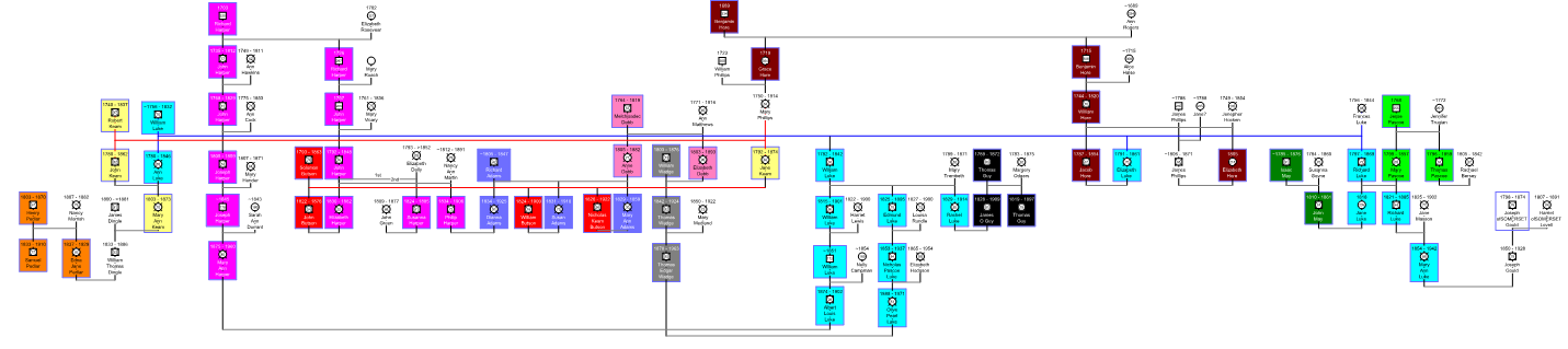
Connections found as of 9 May 2016
Double lines are multiple connections - Click on image for full size
|
by Wesley Johnston The English Corners Project is a local and family history project, intended to document all of the inter-connections of the families of the community of what is now Columbus, Ontario but was originally known as English Corners. Since this was and is a very rural area, those who are buried in the local cemeteries mostly did not actually live in the town. So the scope of the project is not restricted to the limits of the town boundaries but instead encompasses those who considered the town's churches their own. I am seeking to understand who the people of the community were in the period from 1830 to 1860 and to see how these families were related to each other and eventually to other towns to which members of these families migrated, such as the town and greater community of Little Britain in Victoria County. While I am a descendant of one of these families, I live a long way away. So there are probably errors here, and there is probably a lot more to know. My ancestors, Solomon and Jane Butson, and their children, attended St. Paul's Anglican Church and are buried in the cemetery. I visited the town, the church location (the church was already then long gone) and the cemetery in 1977 and took a rubbing of the stone of Solomon & Jane. So this project grew out of the stones in the cemeteries, but it is far more than just a cemetery project. It is an effort to see how these families were connected both in Canada and before that in Cornwall. Clearly the Cornish names in the Methodist cemetery and the Cornish (specifically Luxulyan) origin of the Bible Christian church and the proximity of the Baptist church are also of great significance for the overall project that I have in mind. Nevertheless, I am all too finite in my resources, and I have to start somewhere. So I began this in-depth study with the St. Pauls's Anglican Cemetery page. The other pages will either expand out from the work on those families or will be created when I am done with that cemetery's 1830-1860 families. The Columbus Methodist Cemetery page exists, for example, only because there were family connections to those buried in St. Paul's. This entire project would not have been possible without the extensive work of Christine Ferguson and her son Rob Evans, both of Oshawa, to photograph every one of the stones in the cemeteries, so that they could be included here. Christine is a cousin of my Gibson cousins. (Solomon Butson's son Henry's daughter Emma married John Johnston, who was the half-brother of James Gibson, the ancestor, through his granddaughter Hilda Gibson Clapper, of the cousin who Christine and I share.) Project Database: The project has an Ancestry.com tree, which contains all of the research that I did for these web pages (expect for a couple of the first St. Paul's families that I did). Click here to see that tree, if you are an Ancestry.com member. Since non members cannot see the tree nor the attached documents, you can click here to see a frozen snapshot of the database (with living people privatized). IMPORTANT NOTE: These pages are best viewed in Mozilla Firefox. Microsoft Internet Explorer fails to use widths of images specified as percents and thus greatly distorts the format.
Related Web Page: "From Cornwall to Canada in 1841" is my web page about the 1841 voyage of four ships from Cornwall to Canada. The ships carried 600 Cornish people, mostly from the area of St. Blazey and nearby at St. Austell and Luxulyan. After the long narrative, at the bottom of the web page, I have information about the families and other families that came from the same area of Cornwall to the same area of Canada. For example, the Bealls came in 1840, and there are many Bealls buried in the Columbus Methodist cemetery, and the Butsons came in 1840 and are buried in the Oshawa Pioneer Garden and St. Paul's (as well as at Groveside and Port Perry and -- in the Huron Tract -- Staffa). |
|
The town of Columbus, Ontario was originally called English Corners, probably due to the concentration of so many families of English and Cornish origins who lived there and on the surrounding farms at the southeast part of Ontario County, in East Whitby Township (see 1877 atlas map below). To the south is Oshawa. Even closer to the west is Brooklin (formerly known as Winchester, north of Whitby). Two concessions to the north is the crossroads post office of Raglan (apparently called Newton in 1851), and further north along the same road is Port Perry. If you are using Google Earth, use 43�58'57.26"N and 78�54'41.17"W. Until 1852, there was no Ontario County. Prior to 1852, the townships of what became Ontario County were part of the Eastern Riding of York County. Whitby Township was split vertically in half on January 1, 1858 (under the terms of the Baldwin Act, Chapter 81, Canada Statutes, 1849), with the eastern half becoming Whitby East Township. The lot numbers from 1 to 18 became Whitby East, with the lot numbers from 19 to 36 continuing as Whitby Township. In 1974, Ontario County was dissolved and most of its townships became part of the Regional Municipality of Durham. At that time, East Whitby Township and the city of Oshawa were amalgamated into the city of Oshawa (which had officially become a city in 1924). (See the Ontario County GenWeb and the Ontario Archives page on East Whitby Township for more on this.) A very good site for historic maps of this area is the Port Perry/Scugog Heritage Gallery. |
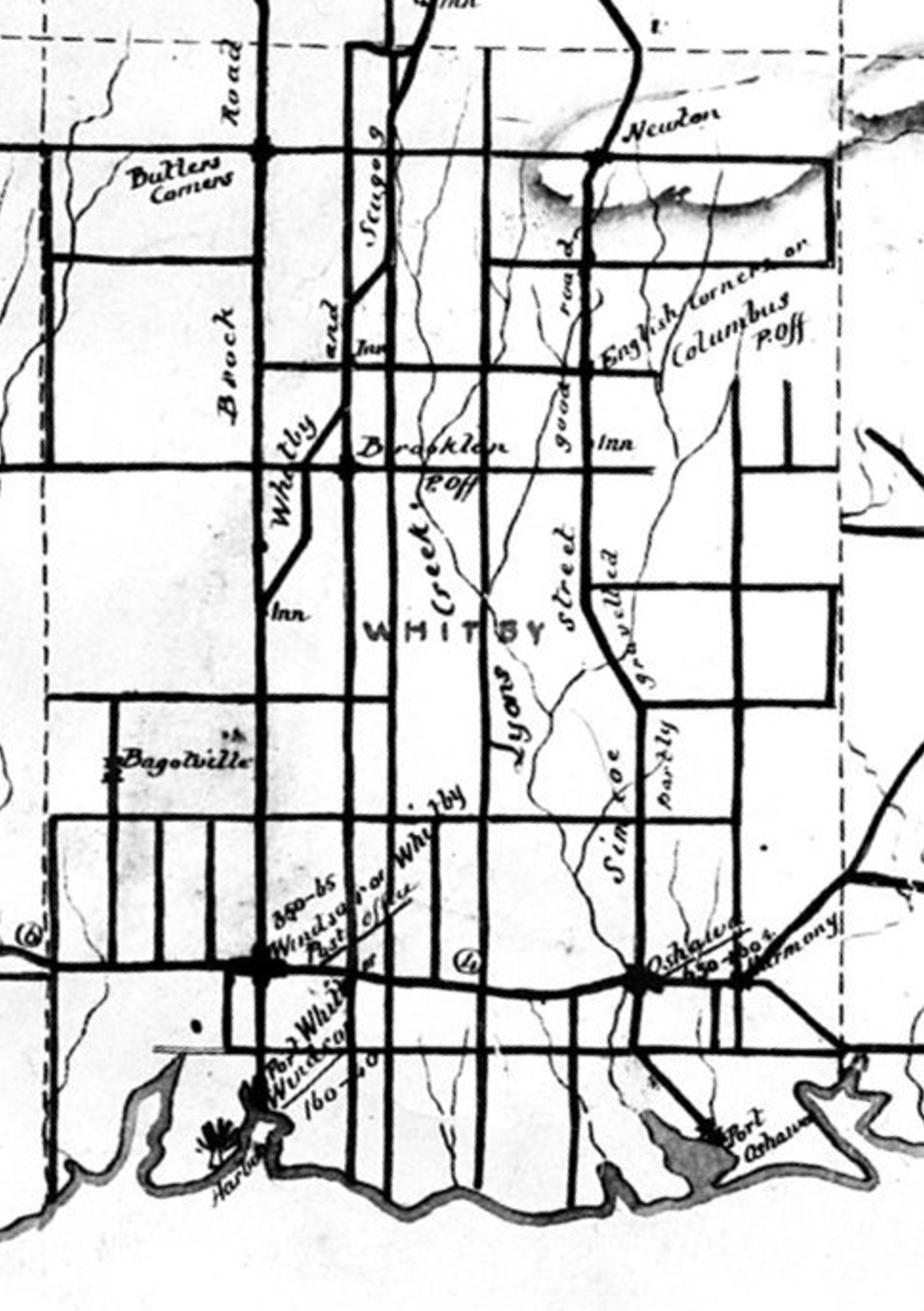
Click on the map to see all of Whitby Township in 1851. Click here to see an 1888 map of south Ontario & Durham Counties. |
|
St. Paul's Anglican Church and Cemetery Click here for my separate web page with much more information about St. Paul's Anglican Cemetery.The cemetery is located just west of Columbus, at the southeast corner of the junction of the east-west road that separates concessions 6 and 7 and the north-south road (now Thornton Road North) that separates lots 16 and 17. If you are using Google Earth, use 43�58'40.08"N and 78�55'49.45"W. At the cemetery, a large a stone reads "Erected on the site of St. Paul's Anglican Church - 1835 - 1935". The 1877 atlas shows no picture of a church building; so it seems likely that only those churches that paid some amount were shown with a drawing on the map. The Whitby Public Library web page that contains the church photograph gives this information: "This church and cemetery were established by Rev. John Pentland in 1835 at lot 16, concession 6, East Whitby Township, on the 7th concession west of Columbus. The church was destroyed by fire on May 2, 1922 when the caretaker, George Browne, was burning the grassy field and the fire got out of control. The cemetery is still used for burials." Another Whitby Public Library web page provides this information about Rev. Pentland "Reverend John Pentland was born in Dublin, Ireland in 1804 and was educated at Kilkenny, Ireland, Trinity College, Dublin; and Cambridge University in England. He served in the British Army from 1824 until he married in 1830 and served in France, Spain and Italy. In 1830 he became a minister of the Church of England and served in Wales, France and Ireland before coming to Canada in 1835. He established his first church in 1835 at Columbus in Whitby Township (St. Paul's Anglican Church). He founded St. John's Anglican Church at Port Whitby in 1841 and built a church of Kingston limestone in 1846. He served as minister of this congregation until his retirement in 1863. He continued to preach in Prince Albert and Port Perry for a while, but poor health caused him to lead a quiet life in Whitby where he died on May 18, 1871. Rev. John Pentland is buried at St. John's Anglican Cemetery, Port Whitby." Yet Another Whitby Public Library web page has his photograph. Baptist The 1877 atlas clearly shows another church and cemetery, just to the west of the St. Paul's cemetery. It was at the junction of the Concession 6-7 road and the road that separates lots 18 and 19. The 1877 atlas clearly shows a cemetery there also, which is visible on Google Earth (43�58'30.85"N and 78�56'27.16"W). This was the Dryden Baptist Church of Columbus. The Ontario Cemeteries web site makes no mention of this cemetery, but Rootsweb does have a Dryden Baptist Cemetery web page, with information about where to purchase a book of transcriptions of the cemetery. The church apparently received the name Dryden from John Dryden, who was born at Brooklin in 1840 (when it was still called Winchester) and is buried at the church. On the map above, he is shown owning land a short distance west of the church, and the land immediately north of the church is owned by James Dryden. John Dryden served in several significant governmental roles. Methodist Click here for my separate web page with much more information about the Columbus Methodist Cemetery. The Durham Genealogical Resources web site does have a transcription of the Columbus Methodist Cemetery, which was in Columbus, between the fourth and fifth houses east of Simcoe Street (43�58�58.11� N, 78�54�32.08�W on Google Earth), though it is not shown in the 1877 atlas. Bible Christian The Columbus Bible Christian cemetery at the west edge of town. It is on the south side of Columbus Road (the old road that separates Concessions 6 and 7), just west of the large building and two houses west of Simcoe Street (43�58'54.94"N, 78�54'45.60"W on Google Earth). It is not on the Ontario Cemeteries web site, nor does it appear in the 1877 atlas. But there is a Rootsweb web page to order a transcription book. According to a Whitby Public Library web page, Frederick William Browne who was born one mile northwest of Columbus in 1870, restored the Columbus Bible Christian cemetery in 1946. Presbyterian The Whitby Public Library has a web page on Rev. Robert Hill Thornton. It states that he founded a Presbyterian church at Columbus, with no date given. An Ajax-Pickering web page states that he had had the small congregation at Columbus for two years at the time of the Mackenzie Rebellion (1837). I have found no mention of where the members of this church were buried. I have found no web site that mentions a Presbyterian cemetery at or near Columbus. Another Ajax-Pickering web page quotes "Past Years in Pickering" that his central church was at "Thornton's Crossroads" and that, from that base, he served people in Columbus, Brooklin, Claremont, Brougham, Pickering and Dunbarton. In 1837, he built a church on the site of Union Cemetery (Oshawa) on the Kingston Road, which is where he is buried and where Presbyterians from Columbus may likely have chosen to be buried. Oshawa Pioneer Memorial Garden Many of the English Corners families had members buried in the early years at the cemetery in Oshawa, which is now the Oshawa Pioneer Memorial Garden at 185 Bond Street in Oshawa, since all of the stones have been combined into a central cairn. I will eventually include these in this site, but for now here are links to some web pages with the names and/or photographs.
|
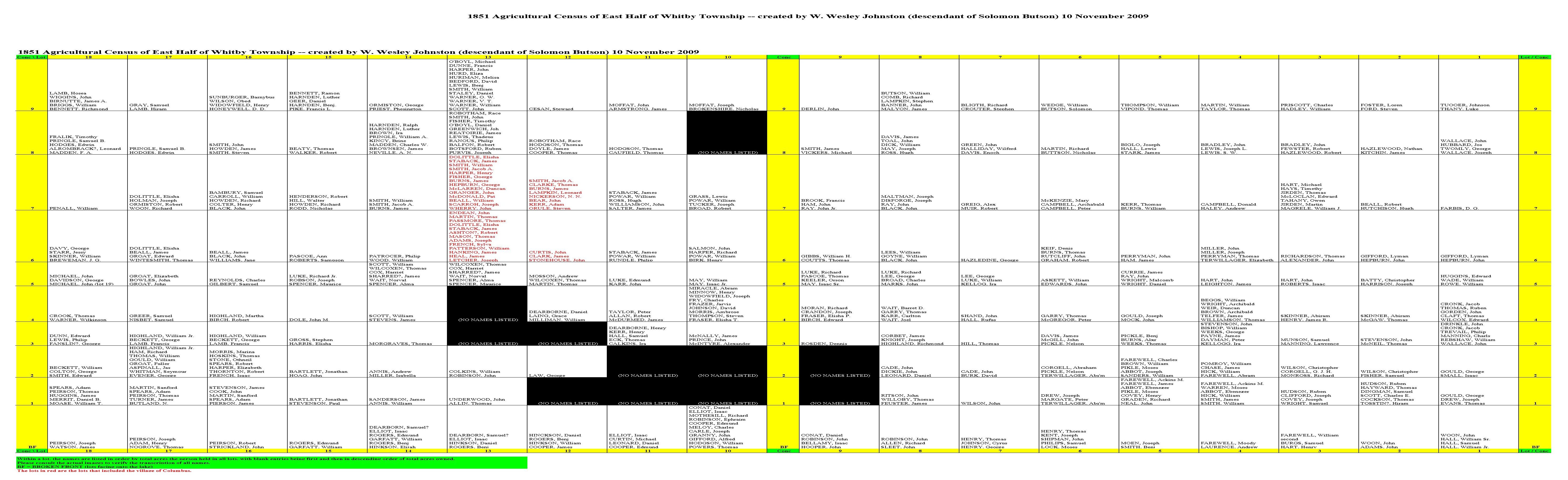
Note that the people buried at the Columbus cemeteries were NOT just from the immediate Columbus area, within the borders of the town. For example, Solomon BUTSON lived on Concession 9 Lot 6, which is several miles northeast of Columbus and even further from the St. Paul's Anglican church and cemetery, where he is buried. Censuses of 1851 and 1861 Since I do not yet know the range, I may have to add to the following. You can click on the links below to see PDF files of the original census images.
|
|
In compiling the information for this project, I have gathered material that is of relevance.
|
|
|